
For decades, scientists watched the Arctic lose ice with growing alarm while Antarctica appeared to hold steady — even expanding in some years. That contrast made the Southern Ocean one of the most puzzling regions on Earth. Then came the shift. Around 2015 and 2016, Antarctic sea ice began declining sharply, and it hasn’t recovered since. The question that has occupied researchers ever since is a straightforward one: what exactly triggered this sudden and sustained collapse?
The answer turned out to be hiding deep beneath the ocean’s surface — in layers of water that no satellite could observe and no ship could safely reach year-round. Solving this mystery required a new kind of scientific tool: autonomous robotic systems capable of operating in one of the harshest and most inaccessible environments on the planet.
Why the Southern Ocean Was So Difficult to Study
Before understanding how technology changed the game, it helps to appreciate just how challenging this region is to study using conventional methods.
Research vessels can operate in the Southern Ocean during summer months, but Antarctic winters make sustained ship-based observation almost impossible. Sea ice covers vast stretches of open water, and storm conditions routinely exceed what crewed vessels can safely handle. Traditional oceanographic equipment — sensors lowered from ships, for instance — can only capture snapshots of what is happening in specific locations at specific times.
What scientists needed was continuous, wide-area data from beneath the ice itself. That kind of observation simply wasn’t possible until autonomous ocean robots became capable and reliable enough to do it.
Enter the Autonomous Ocean Float
The foundation of the modern Antarctic monitoring effort is a network of robotic floats — small, cylindrical devices that drift through the ocean collecting data on temperature, salinity, and pressure at various depths. These floats are part of a global program known as the Argo array, which has been expanding its reach into polar waters over the past two decades.
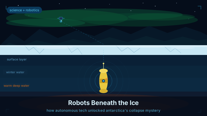
What makes these autonomous devices remarkable is their simplicity in concept but sophistication in execution. Each float adjusts its buoyancy to move up and down through the water column. As it drifts, it collects readings at different depths. When it surfaces — often after days or weeks underwater — it transmits that data via satellite. The process then repeats, autonomously, without any human intervention required.
In the waters around Antarctica, some of these robotic floats travel beneath the seasonal sea ice, continuing to collect data through the winter months when no human presence is possible. They resurface in summer to send their measurements, giving researchers a window into conditions that were previously completely invisible.
From practical experience in oceanographic research, the value of this kind of continuous, subsurface data is hard to overstate. A single reading taken during a summer research voyage tells you what conditions were like on one day in one location. A year’s worth of autonomous float data tells you how the entire water column behaved across an entire season — including the months that matter most for ice formation.
What the Robots Revealed: The Hidden Heat Trap
When researchers compiled and analyzed years of under-ice float data, a clear picture began to emerge that explained the ice collapse ocean crisis in the Southern Ocean.
The key discovery centered on something called ocean stratification — the natural tendency of ocean water to form distinct layers based on differences in temperature and salinity. In a healthy, stable Southern Ocean, a layer of cold, relatively fresh water sits near the surface. This cold surface layer acts as an insulating barrier between the sea ice above and the warmer, saltier water sitting in the deeper ocean below.
For years before 2015, changes in rainfall and precipitation patterns had been freshening this surface layer. Increased rainfall added more fresh water to the ocean’s upper section, making it less dense. This actually strengthened the stratification temporarily — the lighter fresh water stayed near the top, and the heavier, warmer deep water stayed trapped below. In effect, the ocean was quietly accumulating heat in its depths while the surface appeared stable.
What the autonomous robotic floats revealed was the buildup of this hidden heat reservoir over time. The data showed that as the surface layer grew fresher and the stratification intensified, more and more thermal energy was being locked into the deep ocean — energy that couldn’t escape upward under normal conditions.
Then, when unusually powerful wind events hit the region around 2015, they physically disrupted this layered structure. The energy from those storms mixed the water column, breaking down the stratification and allowing the pent-up warmth from the deep ocean to surge upward toward the surface. When that heat reached the underside of the sea ice, the melting process accelerated rapidly, and the ice failed to recover during the subsequent winters.
The Robot That Disappeared — and Came Back With Answers
One of the most compelling stories to emerge from autonomous robotic ocean research in Antarctica involves a single float that went silent beneath the ice for eight months.
As part of the Argo survey program, this bright yellow robotic float drifted beneath the East Antarctic ice shelves — a region scientists describe as one of the least-accessed places on Earth. For months, researchers received no data and feared the device was lost for good. When it finally resurfaced, it delivered something extraordinary: the first-ever ocean data profiles collected from beneath East Antarctic ice shelves.
During its months-long journey of roughly 300 kilometers, the float had collected nearly 200 oceanographic profiles — measurements from the seafloor to the base of the ice taken every five days. The dataset revealed a tale of two ice shelves with very different vulnerabilities: one currently protected from warm water intrusion, and another showing clear signs of exposure to warmer deep ocean currents that put it at risk of accelerating melt.
“We got lucky,” said Steve Rintoul, an oceanographer from Australia’s CSIRO, reflecting on the float’s return. That single sentence captures something important about where autonomous robotic ocean science currently stands — it is still partly dependent on chance and survival in extreme conditions, but the payoffs when things go right are extraordinary.
NASA’s IceNode: The Next Generation of Polar Robots
Building on what floating probes have already taught scientists, NASA’s Jet Propulsion Laboratory is developing a more targeted autonomous system specifically designed for the ice shelf environment. The project, called IceNode, envisions a fleet of robots that would anchor themselves beneath Antarctic ice shelves and take continuous melt-rate measurements over extended periods.
Unlike drifting floats that move wherever currents take them, IceNode robots would be stationed at fixed points where the ice shelf meets the ocean — the precise locations where warm water most directly drives ice loss. The measurements gathered there would feed directly into climate models and help researchers calculate sea level rise projections with far greater precision than is currently possible.
The logic behind this design is straightforward. If you want to understand how fast ice shelves are melting, you need data from the exact point where the melting is happening — not from general ocean profiles taken hundreds of kilometers away. Autonomous robotic systems positioned directly at these critical interfaces can provide that level of detail.
The stakes are significant. Antarctica’s land-based ice sheet, if it were to melt entirely, contains enough water to raise global sea levels by an estimated 60 meters. While complete melting is not an imminent scenario, even partial destabilization of major ice shelves could lead to sea level changes that would affect hundreds of millions of people living in coastal regions.
Ocean Stratification as the Key to Future Prediction
What the autonomous robotic data has given scientists is not just an explanation for what already happened — it has also provided a framework for thinking about what might happen next.
Understanding that ocean stratification was the organizing factor in the ice collapse ocean sequence means that researchers now know what to monitor. Changes in surface water salinity, shifts in the depth and temperature of subsurface warm water masses, and variations in the intensity and frequency of storm events are all now recognized as early warning indicators for potential further ice loss.
Many researchers note that the challenge going forward is not a lack of understanding — it is a lack of data coverage. The current network of autonomous floats around Antarctica, while far more extensive than what existed a decade ago, still leaves significant gaps. The Southern Ocean is vast, and full-season monitoring beneath the ice requires many more devices than are currently deployed.
International coordination is increasingly recognized as essential. Building a comprehensive observing network requires resources and commitment from multiple nations, not just the handful of countries currently leading Antarctic research programs.
Why This Matters Beyond Antarctica
The ice collapse ocean dynamics unfolding in the Southern Ocean don’t stay in the Southern Ocean. The changes ripple outward in two important ways.
First, sea ice acts as a reflective surface that bounces solar radiation back into space. When it disappears, the dark ocean beneath it absorbs that same energy instead. This sets up a self-reinforcing cycle: less ice means more heat absorption, which means less ice in subsequent seasons. The ice collapse ocean feedback loop is one of the reasons climate scientists watch Antarctic sea ice coverage so closely.
Second, the Southern Ocean plays a central role in the global system of ocean circulation — the large-scale movement of water that distributes heat, carbon, and nutrients around the entire planet. Changes in the temperature and salinity of Antarctic waters can affect this circulation on timescales that extend far beyond the local environment, with potential knock-on effects for weather patterns and marine ecosystems worldwide.
The Bigger Picture: Robots Redefining Polar Science
What the autonomous robotic revolution in Antarctic monitoring demonstrates, above all, is that the limits of our scientific understanding are often defined by the limits of our observational tools. For decades, the mystery of the ice collapse ocean transformation in the Southern Ocean persisted not because researchers lacked intelligence or effort, but because they lacked access.
The arrival of capable, reliable autonomous systems that can operate in extreme cold, navigate beneath ice, and transmit data across thousands of kilometers has fundamentally expanded what is observable. And with better observation comes better understanding — and ultimately better preparation for the changes that are already underway.
The robots didn’t solve everything. There are still open questions about the pace of future ice loss, the recovery potential of the Southern Ocean, and the full range of factors driving change in this part of the world. But they moved the conversation from speculation grounded in incomplete data to analysis grounded in direct observation. In the science of climate change, that shift is genuinely significant.